Boll night lights from space
Night Light of Boll (Baden-Württemberg) from space (Germany) Src. Average luminocity for 10x10km area is 10.753% and for 50x50km: 12.16%.
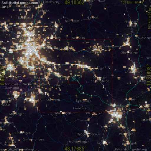
Analysis of Boll night lights 2016
Square area 10x10 km:
 0%
0%90-99
0.45%80-89
0.74%70-79
0%60-69
1.79%50-59
2.38%40-49
2.08%30-39
2.53%20-29
1.64%10-19
16.22%0-9
72.17%Square area 50x50 km:
1.15%90-99
1.51%80-89
0.86%70-79
1.45%60-69
1.53%50-59
1.89%40-49
2.33%30-39
1.91%20-29
3.72%10-19
11%0-9
72.66%Clear (daylight) street map image can be seen on geolist.org.
Map coordinates:
49° 6' 21.7" North, 8° 54' 35.4" East
48° 38' 36.9" North, 9° 36' 46.6" East
48° 10' 36.7" North, 10° 18' 57.9" East
Some cities around Boll sort by population:
• Göppingen
7.3 km =4.5 mi,  23°
23°
• Eislingen
9 km =5.6 mi,  50°
50°
• Ebersbach an der Fils
10.4 km =6.5 mi,  320°
320°
• Uhingen
7.1 km =4.4 mi,  343°
343°
• Weilheim an der Teck
6.4 km =4 mi,  240°
240°
• Deggingen
9.3 km =5.8 mi,  123°
123°
• Rechberghausen
10 km =6.2 mi,  13°
13°
• Heiningen
3.4 km =2.1 mi, 53°
2946696 (p: 5,296)
Sources (retrieved 2019-11-25):
» Earth at Night: Flat Maps 2012, 2016