Bad Wildungen night lights from space
Night Light of Bad Wildungen (Hesse) from space (Germany) Src. Average luminocity for 10x10km area is 3.7647% and for 50x50km: 2.7992%.
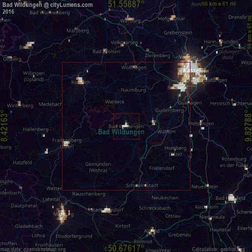
Analysis of Bad Wildungen night lights 2016
Square area 10x10 km:
 0.8%
0.8%90-99
0.8%80-89
0.53%70-79
0.53%60-69
0%50-59
0.53%40-49
0%30-39
0%20-29
1.87%10-19
0.27%0-9
94.65%Square area 50x50 km:
0.47%90-99
0.75%80-89
0.25%70-79
0.34%60-69
0.31%50-59
0.33%40-49
0.27%30-39
0.27%20-29
0.62%10-19
1.29%0-9
95.1%Clear (daylight) street map image can be seen on geolist.org.
Map coordinates:
51° 33' 31.9" North, 8° 25' 17.9" East
51° 7' 10.7" North, 9° 7' 29.1" East
50° 40' 34.2" North, 9° 49' 40.4" East
Some cities around Bad Wildungen sort by population:
• Fritzlar
10.6 km =6.6 mi,  82°
82°
• Borken
13.9 km =8.6 mi,  126°
126°
• Gudensberg
18.1 km =11.2 mi,  69°
69°
• Waldeck
10.5 km =6.5 mi,  335°
335°
• Wabern
15.9 km =9.9 mi,  97°
97°
• Vöhl
15.8 km =9.8 mi,  307°
307°
• Niedenstein
18.1 km =11.2 mi,  45°
45°
• Naumburg
14.6 km =9.1 mi,  11°
11°
2953317 (p: 18,037)
Sources (retrieved 2019-11-25):
» Earth at Night: Flat Maps 2012, 2016