Bad Gandersheim night lights from space
Night Light of Bad Gandersheim (Lower Saxony) from space (Germany) Src. Average luminocity for 10x10km area is 0.5101% and for 50x50km: 1.4987%.
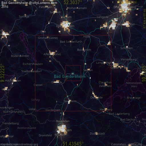
Analysis of Bad Gandersheim night lights 2016
Square area 10x10 km:
 0%
0%90-99
0%80-89
0%70-79
0%60-69
0%50-59
0%40-49
0%30-39
1.01%20-29
0.51%10-19
0%0-9
98.48%Square area 50x50 km:
0.14%90-99
0.21%80-89
0.09%70-79
0.18%60-69
0.37%50-59
0.33%40-49
0.23%30-39
0.24%20-29
0.15%10-19
0.09%0-9
97.97%Clear (daylight) street map image can be seen on geolist.org.
Map coordinates:
52° 18' 13.3" North, 9° 19' 20.1" East
51° 52' 18" North, 10° 1' 31.3" East
51° 26' 7.6" North, 10° 43' 42.6" East
Some cities around Bad Gandersheim sort by population:
• Northeim
18.4 km =11.4 mi,  185°
185°
• Einbeck
12.1 km =7.5 mi,  241°
241°
• Seesen
10.7 km =6.6 mi,  78°
78°
• Alfeld
18.8 km =11.7 mi,  311°
311°
• Bockenem
17 km =10.6 mi,  25°
25°
• Delligsen
17.1 km =10.6 mi,  296°
296°
• Kreiensen
4.6 km =2.9 mi, 244°
• Kalefeld
8 km =5 mi,  176°
176°
2953456 (p: 11,099)
Sources (retrieved 2019-11-25):
» Earth at Night: Flat Maps 2012, 2016