Bad Freienwalde night lights from space
Night Light of Bad Freienwalde (Brandenburg) from space (Germany) Src. Average luminocity for 10x10km area is 1.7614% and for 50x50km: 1.1173%.
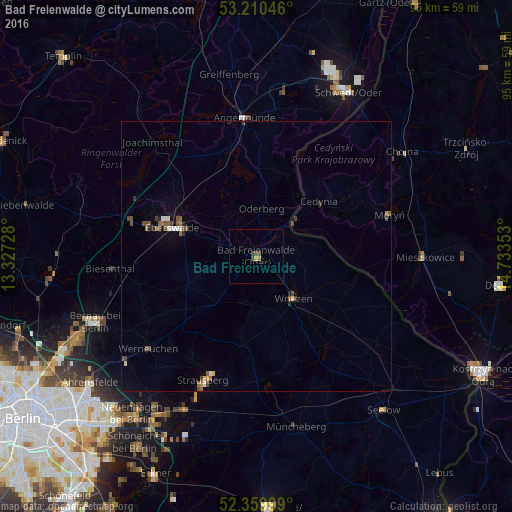
Analysis of Bad Freienwalde night lights 2016
Square area 10x10 km:
 0%
0%90-99
0%80-89
0.25%70-79
0.51%60-69
0.25%50-59
0.13%40-49
1.39%30-39
0.51%20-29
0%10-19
0%0-9
96.97%Square area 50x50 km:
0.07%90-99
0.14%80-89
0.07%70-79
0.08%60-69
0.12%50-59
0.33%40-49
0.43%30-39
0.13%20-29
0.15%10-19
0.11%0-9
98.37%Clear (daylight) street map image can be seen on geolist.org.
Map coordinates:
53° 12' 37.7" North, 13° 19' 38.2" East
52° 47' 14.3" North, 14° 1' 49.4" East
52° 21' 36" North, 14° 44' 0.7" East
Some cities around Bad Freienwalde sort by population:
• Eberswalde
15.1 km =9.4 mi,  290°
290°
• Strausberg
25.1 km =15.6 mi,  202°
202°
• Angermünde
25.4 km =15.8 mi,  355°
355°
• Altlandsberg
32 km =19.9 mi,  219°
219°
• Wriezen
10.2 km =6.3 mi,  136°
136°
• Werneuchen
26.3 km =16.3 mi,  229°
229°
• Müncheberg
32 km =19.9 mi,  166°
166°
• Biesenthal
26.1 km =16.2 mi,  264°
264°
2953458 (p: 13,075)
Sources (retrieved 2019-11-25):
» Earth at Night: Flat Maps 2012, 2016