Mikulov night lights from space
Night Light of Mikulov (South Moravian) from space (Czech Republic) Src. Average luminocity for 10x10km area is 5.0838% and for 50x50km: 2.3619%.
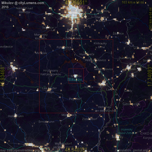
Analysis of Mikulov night lights 2016
Square area 10x10 km:
 1.42%
1.42%90-99
1.42%80-89
0%70-79
0.57%60-69
0%50-59
0%40-49
1.14%30-39
0.99%20-29
0.14%10-19
0%0-9
94.32%Square area 50x50 km:
0.15%90-99
0.3%80-89
0.23%70-79
0.29%60-69
0.24%50-59
0.41%40-49
0.5%30-39
0.52%20-29
0.5%10-19
0.74%0-9
96.12%Clear (daylight) street map image can be seen on geolist.org.
Map coordinates:
49° 15' 59.4" North, 15° 56' 4.8" East
48° 48' 20" North, 16° 38' 16.1" East
48° 20' 25.2" North, 17° 20' 27.3" East
Some cities around Mikulov sort by population:
• Hodonín
36.5 km =22.7 mi,  82°
82°
• Břeclav
18.6 km =11.6 mi,  106°
106°
• Ivančice
38 km =23.6 mi,  329°
329°
• Dubňany
35.3 km =21.9 mi,  69°
69°
• Mistelbach, AT
26.6 km =16.5 mi,  189°
189°
• Moravský Krumlov
36.1 km =22.4 mi,  318°
318°
• Hustopeče
16.7 km =10.4 mi,  25°
25°
• Gbely, SK
36.4 km =22.6 mi, 105°
3070720 (p: 7,608)
Sources (retrieved 2019-11-25):
» Earth at Night: Flat Maps 2012, 2016