Fanzhuang night lights from space
Night Light of Fanzhuang (Tianjin) from space (China) Src. Average luminocity for 10x10km area is 76.461% and for 50x50km: 60.7923%.
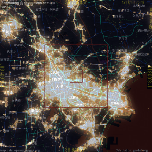
Analysis of Fanzhuang night lights 2016
Square area 10x10 km:
 11.36%
90-99
13.31%80-89
19.81%70-79
20.45%60-69
17.37%50-59
9.74%40-49
6.33%30-39
1.62%20-29
0%10-19
0%0-9
0%Square area 50x50 km:
19.52%90-99
13.14%80-89
9.48%70-79
9.99%60-69
8.31%50-59
4.57%40-49
4.53%30-39
3.41%20-29
3.53%10-19
4.17%0-9
19.35%Clear (daylight) street map image can be seen on geolist.org.
Map coordinates:
39° 44' 11.1" North, 116° 37' 54.8" East
39° 11' 37" North, 117° 20' 6" East
38° 38' 47.7" North, 118° 2' 17.3" East
Some cities around Fanzhuang sort by population:
• Chitu
5.9 km =3.7 mi,  79°
79°
• Zaojiacheng
12.7 km =7.9 mi,  43°
43°
• Huantuo
3.8 km =2.4 mi,  345°
345°
• Dongditou
8.7 km =5.4 mi,  21°
21°
• Dabizhuang
6.8 km =4.2 mi,  269°
269°
• Xiditou
6.8 km =4.2 mi,  9°
9°
• Liukuaizhuang
6 km =3.7 mi,  3°
3°
• Xiaodian
11.4 km =7.1 mi,  305°
305°
1811496 (p: 6,493)
Sources (retrieved 2019-11-25):
» Earth at Night: Flat Maps 2012, 2016