Zürich (Kreis 10) / Wipkingen night lights from space
Night Light of Zürich (Kreis 10) / Wipkingen (Zurich) from space (Switzerland) Src. Average luminocity for 10x10km area is 81.669% and for 50x50km: 17.954%.
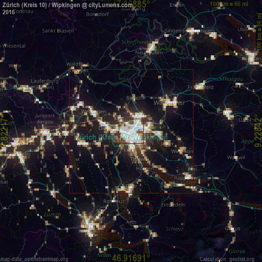
Analysis of Zürich (Kreis 10) / Wipkingen night lights 2016
Square area 10x10 km:
 37.22%
90-99
25%80-89
3.84%70-79
3.84%60-69
4.69%50-59
5.4%40-49
10.65%30-39
8.95%20-29
0.43%10-19
0%0-9
0%Square area 50x50 km:
2.73%90-99
2.83%80-89
1.3%70-79
1.66%60-69
2.56%50-59
2.22%40-49
2.9%30-39
2.96%20-29
4.45%10-19
16.12%0-9
60.27%Clear (daylight) street map image can be seen on geolist.org.
Map coordinates:
47° 52' 7.9" North, 7° 49' 19.8" East
47° 23' 42.1" North, 8° 31' 31" East
46° 55' 0.9" North, 9° 13' 42.3" East
Some cities around Zürich (Kreis 10) / Wipkingen sort by population:
• Zürich
3.7 km =2.3 mi,  149°
149°
• Dübendorf
7 km =4.3 mi,  87°
87°
• Schlieren
5.8 km =3.6 mi,  271°
271°
• Wallisellen
5.8 km =3.6 mi,  67°
67°
• Regensdorf
6.1 km =3.8 mi,  315°
315°
• Oberengstringen
4.8 km =3 mi,  288°
288°
• Rümlang
6.2 km =3.9 mi,  3°
3°
• Wallisellen / Wallisellen-Ost
5.8 km =3.6 mi, 68°
6295475 (p: 15,718)
Sources (retrieved 2019-11-25):
» Earth at Night: Flat Maps 2012, 2016