Ruswil night lights from space
Night Light of Ruswil (Lucerne) from space (Switzerland) Src. Average luminocity for 10x10km area is 4.8182% and for 50x50km: 7.0353%.
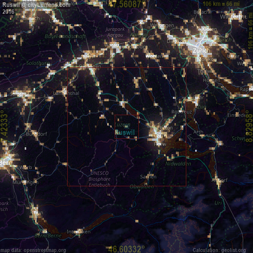
Analysis of Ruswil night lights 2016
Square area 10x10 km:
100  0%
0%
90-99 0%
80-89 0%
70-79 0%
60-69 1.14%
50-59 2.27%
40-49 1.42%
30-39 1.99%
20-29 1.7%
10-19 1.14%
0-9 90.34%
0%90-99
0%80-89
0%70-79
0%60-69
1.14%50-59
2.27%40-49
1.42%30-39
1.99%20-29
1.7%10-19
1.14%0-9
90.34%Square area 50x50 km:
100 0.4%
90-99 0.69%
80-89 0.53%
70-79 0.7%
60-69 1.28%
50-59 1.27%
40-49 1.32%
30-39 1.41%
20-29 1.89%
10-19 4.94%
0-9 85.56%
0.4%90-99
0.69%80-89
0.53%70-79
0.7%60-69
1.28%50-59
1.27%40-49
1.32%30-39
1.41%20-29
1.89%10-19
4.94%0-9
85.56%Clear (daylight) street map image can be seen on geolist.org.
Map coordinates:
47° 33' 39.1" North, 7° 25' 24" East
47° 5' 3.3" North, 8° 7' 35.2" East
46° 36' 12" North, 8° 49' 46.5" East
Some cities around Ruswil sort by population:
• Luzern
14.1 km =8.8 mi,  105°
105°
• Emmen
11.1 km =6.9 mi,  93°
93°
• Kriens
13.4 km =8.3 mi,  116°
116°
• Littau
11 km =6.8 mi, 110°
• Hochdorf
15.6 km =9.7 mi,  53°
53°
• Sursee
9.7 km =6 mi,  353°
353°
• Malters
6.8 km =4.2 mi,  141°
141°
• Neuenkirch
6.1 km =3.8 mi,  73°
73°
2658914 (p: 6,432)
Sources (retrieved 2019-11-25):
» Earth at Night: Flat Maps 2012, 2016