Pinheiral night lights from space
Night Light of Pinheiral (Rio de Janeiro) from space (Brazil) Src. Average luminocity for 10x10km area is 30.5379% and for 50x50km: 13.7615%.
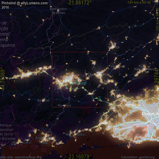
Analysis of Pinheiral night lights 2016
Square area 10x10 km:
 0.57%
0.57%90-99
0.57%80-89
2.84%70-79
4.36%60-69
9.85%50-59
5.11%40-49
6.25%30-39
13.26%20-29
10.04%10-19
27.46%0-9
19.7%Square area 50x50 km:
1.29%90-99
1.34%80-89
1.42%70-79
2.11%60-69
2.62%50-59
2.28%40-49
2.31%30-39
2.55%20-29
3.49%10-19
10.04%0-9
70.55%Clear (daylight) street map image can be seen on geolist.org.
Map coordinates:
21° 51' 42.2" South, 44° 42' 13.3" West
22° 30' 46" South, 44° 0' 2" West
23° 9' 38.8" South, 43° 17' 50.8" West
Some cities around Pinheiral sort by population:
• Volta Redonda
10.7 km =6.6 mi,  263°
263°
• Barra Mansa
17.9 km =11.1 mi, 258°
• Barra do Piraí
18.6 km =11.6 mi,  75°
75°
• Piraí
16.7 km =10.4 mi,  140°
140°
• Mendes
27.5 km =17.1 mi,  93°
93°
• Rio Claro
27.2 km =16.9 mi,  210°
210°
• Porto Real
31.5 km =19.6 mi,  289°
289°
• Quatis
28.9 km =18 mi, 293°
3453767 (p: 19,469)
Sources (retrieved 2019-11-25):
» Earth at Night: Flat Maps 2012, 2016