Nova Floresta night lights from space
Night Light of Nova Floresta (Paraíba) from space (Brazil) Src. Average luminocity for 10x10km area is 11.6732% and for 50x50km: 1.8428%.
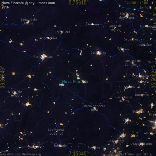
Analysis of Nova Floresta night lights 2016
Square area 10x10 km:
 0.22%
0.22%90-99
1.73%80-89
1.3%70-79
2.38%60-69
2.38%50-59
3.68%40-49
0%30-39
0.87%20-29
0.87%10-19
1.95%0-9
84.63%Square area 50x50 km:
0.16%90-99
0.33%80-89
0.22%70-79
0.23%60-69
0.32%50-59
0.42%40-49
0.16%30-39
0.24%20-29
0.03%10-19
0.28%0-9
97.61%Clear (daylight) street map image can be seen on geolist.org.
Map coordinates:
5° 45' 22.1" South, 36° 54' 23.3" West
6° 27' 19" South, 36° 12' 12" West
7° 9' 12.4" South, 35° 30' 0.8" West
Some cities around Nova Floresta sort by population:
• Currais Novos
40.9 km =25.4 mi,  301°
301°
• Santa Cruz
32.1 km =19.9 mi,  38°
38°
• Cuité
6.3 km =3.9 mi,  119°
119°
• Picuí
17 km =10.6 mi,  248°
248°
• Tangará
52.7 km =32.7 mi,  57°
57°
• Araruna
52.3 km =32.5 mi,  102°
102°
• Cacimba de Dentro
50.1 km =31.1 mi,  114°
114°
• Lagoa Nova
50.2 km =31.2 mi,  321°
321°
3393867 (p: 8,623)
Sources (retrieved 2019-11-25):
» Earth at Night: Flat Maps 2012, 2016