Lagoa do Itaenga night lights from space
Night Light of Lagoa do Itaenga (Pernambuco) from space (Brazil) Src. Average luminocity for 10x10km area is 13.7417% and for 50x50km: 16.107%.
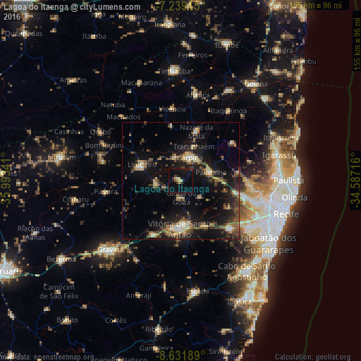
Analysis of Lagoa do Itaenga night lights 2016
Square area 10x10 km:
 0%
0%90-99
0.21%80-89
2.89%70-79
2.69%60-69
0%50-59
1.03%40-49
1.03%30-39
2.48%20-29
3.93%10-19
14.88%0-9
70.87%Square area 50x50 km:
0.53%90-99
1.51%80-89
2.63%70-79
1.3%60-69
2.24%50-59
3.24%40-49
3.16%30-39
2.98%20-29
5.34%10-19
15.13%0-9
61.94%Clear (daylight) street map image can be seen on geolist.org.
Map coordinates:
7° 14' 20.9" South, 35° 59' 36.3" West
7° 56' 10" South, 35° 17' 25" West
8° 37' 54.8" South, 34° 35' 13.8" West
Some cities around Lagoa do Itaenga sort by population:
• Vitória de Santo Antão
20.2 km =12.6 mi,  180°
180°
• Carpina
10.3 km =6.4 mi,  22°
22°
• Limoeiro
18.9 km =11.7 mi,  291°
291°
• Nazaré da Mata
22.7 km =14.1 mi, 17°
• Glória do Goitá
7.3 km =4.5 mi, 182°
• Pombos
25.6 km =15.9 mi,  206°
206°
• Araçoiaba
27.3 km =17 mi,  53°
53°
• Feira Nova
11 km =6.8 mi,  261°
261°
3396769 (p: 17,719)
Sources (retrieved 2019-11-25):
» Earth at Night: Flat Maps 2012, 2016