Tvarditsa night lights from space
Night Light of Tvarditsa (Sliven) from space (Bulgaria) Src. Average luminocity for 10x10km area is 2.6939% and for 50x50km: 0.8347%.
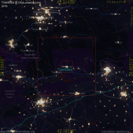
Analysis of Tvarditsa night lights 2016
Square area 10x10 km:
 0.3%
0.3%90-99
0.3%80-89
0%70-79
0%60-69
0.61%50-59
0.61%40-49
1.21%30-39
0.61%20-29
1.21%10-19
0%0-9
95.15%Square area 50x50 km:
0.02%90-99
0.06%80-89
0.08%70-79
0.08%60-69
0.14%50-59
0.08%40-49
0.31%30-39
0.28%20-29
0.32%10-19
0.21%0-9
98.42%Clear (daylight) street map image can be seen on geolist.org.
Map coordinates:
43° 12' 52.5" North, 25° 11' 48.8" East
42° 42' 0" North, 25° 54' 0" East
42° 10' 52" North, 26° 36' 11.3" East
Some cities around Tvarditsa sort by population:
• Stara Zagora
36.5 km =22.7 mi,  215°
215°
• Sliven
35.1 km =21.8 mi,  92°
92°
• Kazanlak
41.9 km =26 mi,  257°
257°
• Nova Zagora
25.9 km =16.1 mi,  158°
158°
• Radnevo
44.6 km =27.7 mi,  176°
176°
• Tryavna
37.5 km =23.3 mi,  299°
299°
• Dryanovo
46.3 km =28.8 mi,  312°
312°
• Elena
26 km =16.2 mi,  357°
357°
726130 (p: 6,519)
Sources (retrieved 2019-11-25):
» Earth at Night: Flat Maps 2012, 2016