Nieuwpoort night lights from space
Night Light of Nieuwpoort (Flanders) from space (Belgium) Src. Average luminocity for 10x10km area is 31.9505% and for 50x50km: 12.577%.
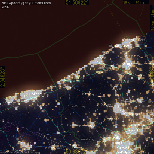
Analysis of Nieuwpoort night lights 2016
Square area 10x10 km:
 4.01%
4.01%90-99
4.95%80-89
3.34%70-79
4.28%60-69
3.74%50-59
4.68%40-49
4.41%30-39
3.61%20-29
7.75%10-19
43.45%0-9
15.78%Square area 50x50 km:
1.84%90-99
2.09%80-89
1.05%70-79
1.17%60-69
1.18%50-59
1.36%40-49
1.43%30-39
1.54%20-29
4.53%10-19
13.97%0-9
69.84%Clear (daylight) street map image can be seen on geolist.org.
Map coordinates:
51° 34' 9.2" North, 2° 2' 53.6" East
51° 7' 48.3" North, 2° 45' 4.9" East
50° 41' 12.2" North, 3° 27' 16.1" East
Some cities around Nieuwpoort sort by population:
• Ostend
15.5 km =9.6 mi,  52°
52°
• Koksijde
8.1 km =5 mi,  259°
259°
• Middelkerke
7.8 km =4.8 mi,  38°
38°
• Diksmuide
13.4 km =8.3 mi,  144°
144°
• Veurne
8.6 km =5.3 mi,  222°
222°
• Gistel
15.1 km =9.4 mi,  78°
78°
• De Panne
11.6 km =7.2 mi,  252°
252°
• Oostduinkerke
5.1 km =3.2 mi, 251°
2790150 (p: 10,845)
Sources (retrieved 2019-11-25):
» Earth at Night: Flat Maps 2012, 2016