Eeklo night lights from space
Night Light of Eeklo (Flanders) from space (Belgium) Src. Average luminocity for 10x10km area is 32.746% and for 50x50km: 30.4208%.
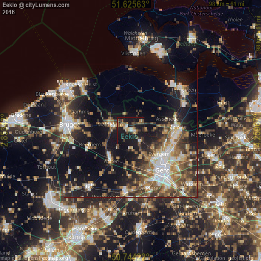
Analysis of Eeklo night lights 2016
Square area 10x10 km:
 2.54%
2.54%90-99
4.14%80-89
2.41%70-79
4.41%60-69
5.21%50-59
4.41%40-49
8.29%30-39
4.41%20-29
6.82%10-19
54.28%0-9
3.07%Square area 50x50 km:
4.71%90-99
5.22%80-89
3%70-79
3.8%60-69
4.36%50-59
4.69%40-49
5.11%30-39
4.86%20-29
7.98%10-19
20.42%0-9
35.85%Clear (daylight) street map image can be seen on geolist.org.
Map coordinates:
51° 37' 32.3" North, 2° 51' 12.3" East
51° 11' 13.3" North, 3° 33' 23.5" East
50° 44' 39.2" North, 4° 15' 34.8" East
Some cities around Eeklo sort by population:
• Maldegem
8.1 km =5 mi,  286°
286°
• Aalter
13.2 km =8.2 mi,  215°
215°
• Lovendegem
10.3 km =6.4 mi,  157°
157°
• Zomergem
7.5 km =4.7 mi,  175°
175°
• Knesselare
11.3 km =7 mi,  242°
242°
• Waarschoot
5.1 km =3.2 mi,  138°
138°
• Sint-Laureins
6.5 km =4 mi,  339°
339°
• Kaprijke
5.3 km =3.3 mi,  50°
50°
2798987 (p: 19,116)
Sources (retrieved 2019-11-25):
» Earth at Night: Flat Maps 2012, 2016