Sakhipur night lights from space
Night Light of Sakhipur (Dhaka) from space (Bangladesh) Src. Average luminocity for 10x10km area is 22.8182% and for 50x50km: 16.5692%.

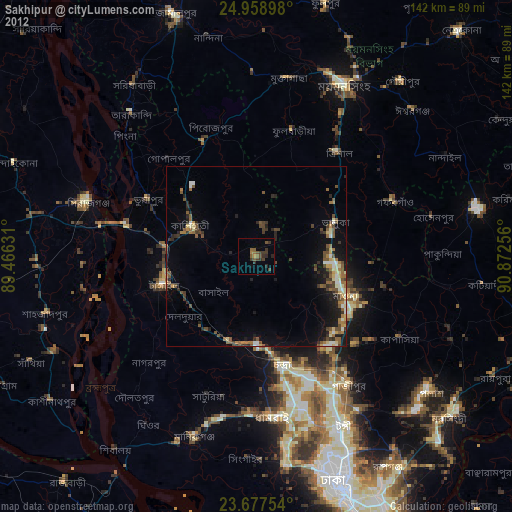
Analysis of Sakhipur night lights 2016
Square area 10x10 km:
 0%
0%90-99
0%80-89
1.7%70-79
1.33%60-69
2.27%50-59
3.03%40-49
8.33%30-39
11.74%20-29
17.61%10-19
21.78%0-9
32.2%Square area 50x50 km:
1.09%90-99
1.98%80-89
1.04%70-79
1.47%60-69
2.13%50-59
2.77%40-49
4.42%30-39
4.95%20-29
6.35%10-19
13.7%0-9
60.11%Clear (daylight) street map image can be seen on geolist.org.
Map coordinates:
24° 57' 32.3" North, 89° 27' 58.7" East
24° 19' 11.6" North, 90° 10' 9.9" East
23° 40' 39.1" North, 90° 52' 21.2" East
Some cities around Sakhipur sort by population:
• Tungi
53.2 km =33.1 mi,  153°
153°
• Nāgarpur
41.6 km =25.8 mi,  225°
225°
• Mymensingh
54.1 km =33.6 mi,  26°
26°
• Tāngāil
26.8 km =16.7 mi,  253°
253°
• Sirajganj
49.2 km =30.6 mi,  288°
288°
• Mirzāpur
25.2 km =15.7 mi,  196°
196°
• Gafargaon
41.3 km =25.7 mi,  72°
72°
• Muktāgācha
50.3 km =31.3 mi,  10°
10°
1189056 (p: 40,869)
Sources (retrieved 2019-11-25):
» Earth at Night: Flat Maps 2012, 2016