Velika Kladuša night lights from space
Night Light of Velika Kladuša (Federation of B&H) from space (Bosnia and Herzegovina) Src. Average luminocity for 10x10km area is 2.897% and for 50x50km: 0.7395%.
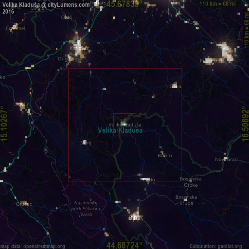
Analysis of Velika Kladuša night lights 2016
Square area 10x10 km:
 0.15%
0.15%90-99
0.45%80-89
0.3%70-79
0.3%60-69
0%50-59
0%40-49
1.82%30-39
0.91%20-29
0.61%10-19
1.52%0-9
93.94%Square area 50x50 km:
0.08%90-99
0.16%80-89
0.04%70-79
0.06%60-69
0.06%50-59
0.12%40-49
0.21%30-39
0.15%20-29
0.21%10-19
0.18%0-9
98.73%Clear (daylight) street map image can be seen on geolist.org.
Map coordinates:
45° 40' 42.2" North, 15° 6' 9.6" East
45° 11' 5.9" North, 15° 48' 20.8" East
44° 41' 14.1" North, 16° 30' 32.1" East
Some cities around Velika Kladuša sort by population:
• Todorovo
14.5 km =9 mi,  137°
137°
• Vrnograč
11.9 km =7.4 mi,  101°
101°
• Podzvizd
5.4 km =3.4 mi, 102°
• Varoška Rijeka
19.8 km =12.3 mi,  122°
122°
• Pećigrad
16.2 km =10.1 mi,  153°
153°
• Mala Kladuša
6.7 km =4.2 mi, 147°
• Ćoralići
20.5 km =12.7 mi,  165°
165°
• Šturlić
13.6 km =8.5 mi,  189°
189°
3188225 (p: 19,330)
Sources (retrieved 2019-11-25):
» Earth at Night: Flat Maps 2012, 2016