Yanchep night lights from space
Night Light of Yanchep (Western Australia) from space (Australia) Src. Average luminocity for 10x10km area is 13.0892% and for 50x50km: 6.415%.
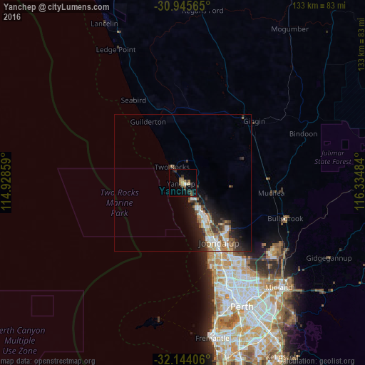
Analysis of Yanchep night lights 2016
Square area 10x10 km:
 0.52%
0.52%90-99
0.35%80-89
1.22%70-79
1.75%60-69
4.55%50-59
1.75%40-49
1.57%30-39
2.8%20-29
2.1%10-19
9.27%0-9
74.13%Square area 50x50 km:
1.05%90-99
0.98%80-89
0.4%70-79
0.61%60-69
1.37%50-59
0.98%40-49
0.8%30-39
1.15%20-29
1.9%10-19
4.1%0-9
86.65%Clear (daylight) street map image can be seen on geolist.org.
Map coordinates:
30° 56' 44.3" South, 114° 55' 42.9" East
31° 32' 48.4" South, 115° 37' 54.2" East
32° 8' 38.6" South, 116° 20' 5.4" East
Some cities around Yanchep sort by population:
• Butler
12.7 km =7.9 mi,  147°
147°
• Clarkson
17.5 km =10.9 mi, 149°
• Quinns Rocks
15.7 km =9.8 mi, 154°
• Mindarie
17.4 km =10.8 mi,  155°
155°
• Carramar
20.7 km =12.9 mi,  140°
140°
• Kinross
21.6 km =13.4 mi, 152°
• Alkimos
10.6 km =6.6 mi, 150°
• Merriwa
15.2 km =9.4 mi, 149°
2057575 (p: 8,571)
Sources (retrieved 2019-11-25):
» Earth at Night: Flat Maps 2012, 2016