Bentley night lights from space
Night Light of Bentley (Western Australia) from space (Australia) Src. Average luminocity for 10x10km area is 92.7517% and for 50x50km: 42.6721%.
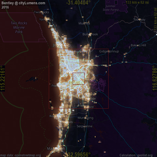
Analysis of Bentley night lights 2016
Square area 10x10 km:
 34.97%
90-99
34.27%80-89
15.03%70-79
14.51%60-69
1.22%50-59
0%40-49
0%30-39
0%20-29
0%10-19
0%0-9
0%Square area 50x50 km:
9.35%90-99
10.16%80-89
4.82%70-79
6.52%60-69
8.38%50-59
4.98%40-49
3.56%30-39
3.82%20-29
7.07%10-19
8.68%0-9
32.65%Clear (daylight) street map image can be seen on geolist.org.
Map coordinates:
31° 24' 14.5" South, 115° 13' 17.8" East
32° 0' 8.1" South, 115° 55' 29" East
32° 35' 47.6" South, 116° 37' 40.3" East
Some cities around Bentley sort by population:
• East Victoria Park
2.5 km =1.6 mi,  306°
306°
• Victoria Park
3.4 km =2.1 mi,  327°
327°
• Kewdale
3.6 km =2.2 mi,  44°
44°
• Queens Park
2 km =1.2 mi,  92°
92°
• Carlisle
2.6 km =1.6 mi,  346°
346°
• Wilson
2.4 km =1.5 mi,  210°
210°
• Cannington
1.9 km =1.2 mi,  144°
144°
• East Cannington
3 km =1.9 mi,  106°
106°
2076752 (p: 8,323)
Sources (retrieved 2019-11-25):
» Earth at Night: Flat Maps 2012, 2016