Alaverdi night lights from space
Night Light of Alaverdi (Lori) from space (Armenia) Src. Average luminocity for 10x10km area is 0.2922% and for 50x50km: 0.1866%.
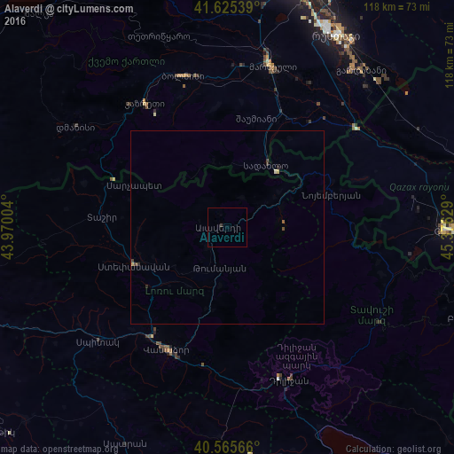
Analysis of Alaverdi night lights 2016
Square area 10x10 km:
 0%
0%90-99
0%80-89
0%70-79
0%60-69
0%50-59
0%40-49
0%30-39
0.65%20-29
0%10-19
0%0-9
99.35%Square area 50x50 km:
0%90-99
0.01%80-89
0.07%70-79
0%60-69
0%50-59
0.03%40-49
0.09%30-39
0.1%20-29
0.04%10-19
0.02%0-9
99.65%Clear (daylight) street map image can be seen on geolist.org.
Map coordinates:
41° 37' 31.4" North, 43° 58' 12.1" East
41° 5' 51.6" North, 44° 40' 23.4" East
40° 33' 56.4" North, 45° 22' 34.6" East
Some cities around Alaverdi sort by population:
• Vanadzor
35.9 km =22.3 mi,  204°
204°
• Step’anavan
26 km =16.2 mi,  247°
247°
• Marneuli, GE
43.6 km =27.1 mi,  15°
15°
• Bolnisi, GE
40.5 km =25.2 mi,  343°
343°
• Dilijan
42.3 km =26.3 mi,  159°
159°
• Tashir
32.7 km =20.3 mi,  274°
274°
• Naghvarevi, GE
29.3 km =18.2 mi,  14°
14°
• Noyemberyan
28.5 km =17.7 mi,  73°
73°
616974 (p: 13,184)
Sources (retrieved 2019-11-25):
» Earth at Night: Flat Maps 2012, 2016