Los Lunas night lights from space
Night Light of Los Lunas (New Mexico) from space (United States) Src. Average luminocity for 10x10km area is 45.4212% and for 50x50km: 8.7489%.
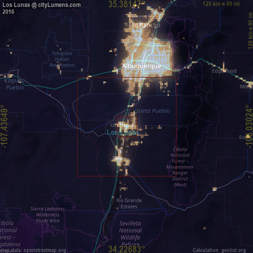
Analysis of Los Lunas night lights 2016
Square area 10x10 km:
 3.66%
3.66%90-99
4.03%80-89
3.11%70-79
16.3%60-69
9.71%50-59
6.04%40-49
7.14%30-39
8.24%20-29
15.75%10-19
24.73%0-9
1.28%Square area 50x50 km:
0.4%90-99
0.47%80-89
0.44%70-79
2.39%60-69
1.67%50-59
1.08%40-49
1.83%30-39
1.89%20-29
2.72%10-19
8.49%0-9
78.62%Clear (daylight) street map image can be seen on geolist.org.
Map coordinates:
35° 22' 53.3" North, 107° 26' 11.4" West
34° 48' 22.2" North, 106° 44' 0.1" West
34° 13' 36.6" North, 106° 1' 48.9" West
Some cities around Los Lunas sort by population:
• Albuquerque
31.8 km =19.8 mi,  13°
13°
• Rio Rancho
47.9 km =29.8 mi, 7°
• South Valley
23.2 km =14.4 mi, 12°
• North Valley
42 km =26.1 mi, 13°
• Belen
16.4 km =10.2 mi,  193°
193°
• Los Ranchos de Albuquerque
40.4 km =25.1 mi, 11°
• Lee Acres
38.9 km =24.2 mi, 11°
• Los Chavez
9.2 km =5.7 mi, 193°
5476913 (p: 15,336)
Sources (retrieved 2019-11-25):
» Earth at Night: Flat Maps 2012, 2016