Demre night lights from space
Night Light of Demre (Antalya) from space (Turkey) Src. Average luminocity for 10x10km area is 36.0455% and for 50x50km: 5.5078%.
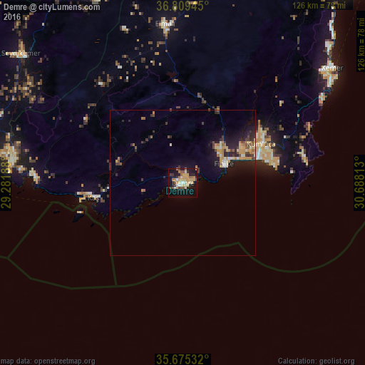
Analysis of Demre night lights 2016
Square area 10x10 km:
100  1.05%
1.05%
90-99 6.64%
80-89 6.29%
70-79 11.36%
60-69 4.55%
50-59 4.37%
40-49 2.62%
30-39 3.5%
20-29 4.55%
10-19 36.01%
0-9 19.06%
1.05%90-99
6.64%80-89
6.29%70-79
11.36%60-69
4.55%50-59
4.37%40-49
2.62%30-39
3.5%20-29
4.55%10-19
36.01%0-9
19.06%Square area 50x50 km:
100 0.15%
90-99 0.77%
80-89 0.67%
70-79 1.42%
60-69 0.62%
50-59 0.53%
40-49 0.68%
30-39 0.92%
20-29 1.72%
10-19 5.05%
0-9 87.47%
0.15%90-99
0.77%80-89
0.67%70-79
1.42%60-69
0.62%50-59
0.53%40-49
0.68%30-39
0.92%20-29
1.72%10-19
5.05%0-9
87.47%Clear (daylight) street map image can be seen on geolist.org.
Map coordinates:
36° 48' 34" North, 29° 16' 54.8" East
36° 14' 40" North, 29° 59' 6" East
35° 40' 31.2" North, 30° 41' 17.3" East
Some cities around Demre sort by population:
• Beykonak
29.9 km =18.6 mi,  72°
72°
• Tekirova
56.3 km =35 mi,  59°
59°
• Kemer
64.8 km =40.3 mi,  52°
52°
• Elmalı
55 km =34.2 mi,  353°
353°
• Finike
15 km =9.3 mi, 68°
• Turunçova
19.4 km =12.1 mi,  44°
44°
• Kaş
31.5 km =19.6 mi,  261°
261°
• Göynük
68.5 km =42.6 mi, 47°
295781 (p: 14,420)
Sources (retrieved 2019-11-25):
» Earth at Night: Flat Maps 2012, 2016