Yemel’yanovo night lights from space
Night Light of Yemel’yanovo (Krasnoyarskiy) from space (Russia) Src. Average luminocity for 10x10km area is 17.4737% and for 50x50km: 15.9089%.
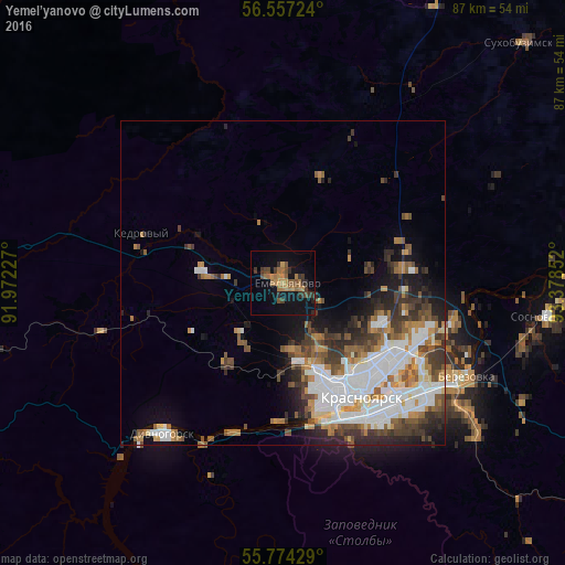
Analysis of Yemel’yanovo night lights 2016
Square area 10x10 km:
 0%
0%90-99
0%80-89
0%70-79
5.5%60-69
5.62%50-59
2.99%40-49
2.99%30-39
5.14%20-29
2.75%10-19
16.15%0-9
58.85%Square area 50x50 km:
4.24%90-99
3%80-89
0.82%70-79
1.96%60-69
2.02%50-59
2.18%40-49
2.41%30-39
2.78%20-29
3.03%10-19
4.86%0-9
72.7%Clear (daylight) street map image can be seen on geolist.org.
Map coordinates:
56° 33' 26.1" North, 91° 58' 20.2" East
56° 10' 3.9" North, 92° 40' 31.4" East
55° 46' 27.4" North, 93° 22' 42.7" East
Some cities around Yemel’yanovo sort by population:
• Krasnoyarsk
20.4 km =12.7 mi,  144°
144°
• Zheleznogorsk
53.8 km =33.4 mi,  80°
80°
• Sosnovoborsk
41.4 km =25.7 mi,  97°
97°
• Divnogorsk
29.9 km =18.6 mi,  218°
218°
• Berëzovka
31.1 km =19.3 mi,  119°
119°
• Solnechnyy
16.5 km =10.3 mi,  110°
110°
• Zykovo
38.3 km =23.8 mi,  128°
128°
• Kedrovyy
71.5 km =44.4 mi,  280°
280°
1486031 (p: 10,800)
Sources (retrieved 2019-11-25):
» Earth at Night: Flat Maps 2012, 2016