Vinzili night lights from space
Night Light of Vinzili (Tyumen’ Oblast) from space (Russia) Src. Average luminocity for 10x10km area is 8.8614% and for 50x50km: 10.778%.
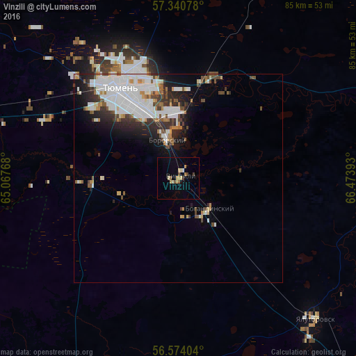
Analysis of Vinzili night lights 2016
Square area 10x10 km:
 0.11%
0.11%90-99
0.45%80-89
2.61%70-79
1.93%60-69
0.8%50-59
0.91%40-49
1.36%30-39
0.23%20-29
0.23%10-19
0.34%0-9
91.02%Square area 50x50 km:
3.62%90-99
2.53%80-89
0.63%70-79
0.66%60-69
0.82%50-59
1.05%40-49
1.09%30-39
1.3%20-29
2.27%10-19
3.54%0-9
82.47%Clear (daylight) street map image can be seen on geolist.org.
Map coordinates:
57° 20' 26.8" North, 65° 4' 3.6" East
56° 57' 33.8" North, 65° 46' 14.9" East
56° 34' 26.5" North, 66° 28' 26.1" East
Some cities around Vinzili sort by population:
• Tyumen
26 km =16.2 mi,  325°
325°
• Yalutorovsk
46.9 km =29.1 mi,  136°
136°
• Borovskiy
9.6 km =6 mi,  341°
341°
• Bogandinskiy
10.4 km =6.5 mi,  134°
134°
• Isetskoye
59.3 km =36.8 mi,  207°
207°
• Tugulym
69.2 km =43 mi,  279°
279°
• Melioratorov
29.6 km =18.4 mi, 340°
• Antipino
16.4 km =10.2 mi,  357°
357°
1487086 (p: 11,219)
Sources (retrieved 2019-11-25):
» Earth at Night: Flat Maps 2012, 2016