Krasnoarmeysk night lights from space
Night Light of Krasnoarmeysk (Moscow Oblast) from space (Russia) Src. Average luminocity for 10x10km area is 6.0945% and for 50x50km: 18.0756%.
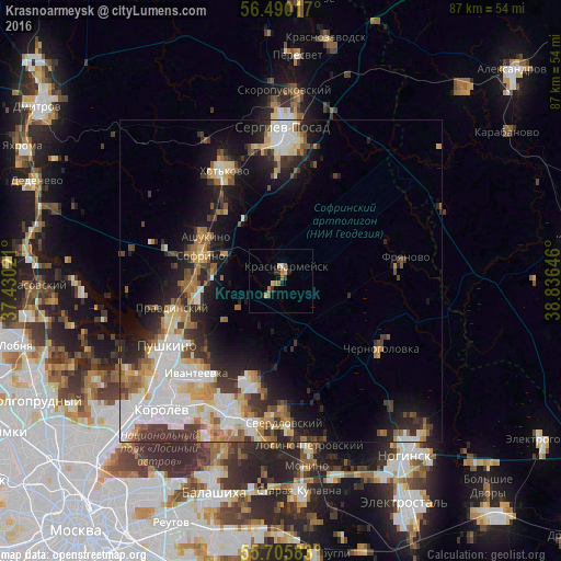

Analysis of Krasnoarmeysk night lights 2016
Square area 10x10 km:
 0.36%
0.36%90-99
0.12%80-89
1.44%70-79
0.72%60-69
1.44%50-59
1.2%40-49
0.48%30-39
1.56%20-29
1.32%10-19
0.48%0-9
90.91%Square area 50x50 km:
4.25%90-99
3.43%80-89
2.07%70-79
1.99%60-69
2.29%50-59
2.02%40-49
1.76%30-39
3.04%20-29
4.34%10-19
8.13%0-9
66.68%Clear (daylight) street map image can be seen on geolist.org.
Map coordinates:
56° 29' 24.6" North, 37° 25' 48.8" East
56° 6' 0" North, 38° 7' 60" East
55° 42' 21" North, 38° 50' 11.3" East
Some cities around Krasnoarmeysk sort by population:
• Pushkino
18.9 km =11.7 mi,  240°
240°
• Fryazino
16.4 km =10.2 mi,  199°
199°
• Chernogolovka
18.3 km =11.4 mi,  127°
127°
• Sofrino
13.6 km =8.5 mi,  294°
294°
• Pravdinskiy
17.4 km =10.8 mi,  255°
255°
• Lesnoy
13.9 km =8.6 mi,  254°
254°
• Muranovo
17.2 km =10.7 mi,  302°
302°
• Ashukino
13.6 km =8.5 mi, 303°
542463 (p: 25,688)
Sources (retrieved 2019-11-25):
» Earth at Night: Flat Maps 2012, 2016