Dedenëvo night lights from space
Night Light of Dedenëvo (Moscow Oblast) from space (Russia) Src. Average luminocity for 10x10km area is 26.5801% and for 50x50km: 11.5037%.
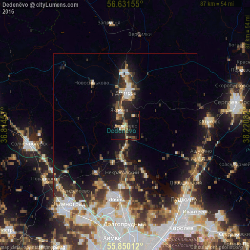
Analysis of Dedenëvo night lights 2016
Square area 10x10 km:
 1.32%
1.32%90-99
3.71%80-89
2.99%70-79
3.47%60-69
4.31%50-59
5.26%40-49
4.07%30-39
2.63%20-29
7.54%10-19
34.93%0-9
29.78%Square area 50x50 km:
1.04%90-99
1.34%80-89
1.01%70-79
1.38%60-69
1.74%50-59
1.76%40-49
2.09%30-39
2.84%20-29
4.71%10-19
10.33%0-9
71.76%Clear (daylight) street map image can be seen on geolist.org.
Map coordinates:
56° 37' 53.6" North, 36° 48' 52.5" East
56° 14' 34.2" North, 37° 31' 3.7" East
55° 51' 0.4" North, 38° 13' 15" East
Some cities around Dedenëvo sort by population:
• Lobnya
26 km =16.2 mi,  184°
184°
• Dmitrov
11.3 km =7 mi,  0°
0°
• Sofrino
27.7 km =17.2 mi,  111°
111°
• Yakhroma
6.7 km =4.2 mi,  341°
341°
• Nekrasovskiy
16.6 km =10.3 mi, 183°
• Novosin’kovo
19 km =11.8 mi,  322°
322°
• Muranovo
24.5 km =15.2 mi, 105°
• Ashukino
28 km =17.4 mi, 107°
566891 (p: 6,455)
Sources (retrieved 2019-11-25):
» Earth at Night: Flat Maps 2012, 2016