Alpatovo night lights from space
Night Light of Alpatovo (Chechnya) from space (Russia) Src. Average luminocity for 10x10km area is 1.0121% and for 50x50km: 2.1322%.
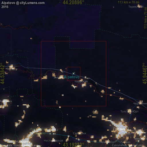
Analysis of Alpatovo night lights 2016
Square area 10x10 km:
 0%
0%90-99
0%80-89
0%70-79
0%60-69
0.61%50-59
0%40-49
0%30-39
0%20-29
0%10-19
0.61%0-9
98.79%Square area 50x50 km:
0.09%90-99
0.2%80-89
0.3%70-79
0.19%60-69
0.51%50-59
0.46%40-49
0.41%30-39
0.22%20-29
0.31%10-19
0.39%0-9
96.93%Clear (daylight) street map image can be seen on geolist.org.
Map coordinates:
44° 12' 32.3" North, 44° 32' 18.3" East
43° 42' 10.1" North, 45° 14' 29.5" East
43° 11' 32.4" North, 45° 56' 40.8" East
Some cities around Alpatovo sort by population:
• Znamenskoye
9.5 km =5.9 mi,  253°
253°
• Naurskaya
8.1 km =5 mi,  135°
135°
• Kalinovskaya
26.7 km =16.6 mi,  122°
122°
• Lakha Nëvre
11.9 km =7.4 mi, 138°
• Elin-Yurt
23 km =14.3 mi,  261°
261°
• Benoy-Yurt
15.4 km =9.6 mi,  265°
265°
• Nogamerzin-Yurt
28.9 km =18 mi, 259°
• Lakkha Nëvre
10.3 km =6.4 mi,  178°
178°
523210 (p: 5,192)
Sources (retrieved 2019-11-25):
» Earth at Night: Flat Maps 2012, 2016