Ostroveni night lights from space
Night Light of Ostroveni (Dolj) from space (Romania) Src. Average luminocity for 10x10km area is 2.3106% and for 50x50km: 1.0783%.
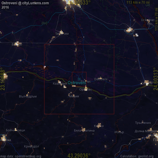
Analysis of Ostroveni night lights 2016
Square area 10x10 km:
 0.3%
0.3%90-99
0.61%80-89
0.3%70-79
0%60-69
0.61%50-59
0.3%40-49
0%30-39
0.61%20-29
0%10-19
0%0-9
97.27%Square area 50x50 km:
0.09%90-99
0.16%80-89
0.13%70-79
0.04%60-69
0.1%50-59
0.19%40-49
0.2%30-39
0.4%20-29
0.4%10-19
0.12%0-9
98.17%Clear (daylight) street map image can be seen on geolist.org.
Map coordinates:
44° 18' 19.2" North, 23° 11' 48.8" East
43° 48' 0" North, 23° 54' 0" East
43° 17' 25.3" North, 24° 36' 11.3" East
Some cities around Ostroveni sort by population:
• Kozloduy, BG
14.6 km =9.1 mi,  260°
260°
• Dăbuleni
14.7 km =9.1 mi,  90°
90°
• Sadova
11.8 km =7.3 mi,  19°
19°
• Dăneţi
23.7 km =14.7 mi,  30°
30°
• Călăraşi
12 km =7.5 mi, 90°
• Valea Stanciului
20.6 km =12.8 mi,  352°
352°
• Amărăştii de Jos
27.1 km =16.8 mi,  52°
52°
• Oryahovo, BG
8.6 km =5.3 mi,  145°
145°
671626 (p: 5,731)
Sources (retrieved 2019-11-25):
» Earth at Night: Flat Maps 2012, 2016