Negreşti-Oaş night lights from space
Night Light of Negreşti-Oaş (Satu Mare) from space (Romania) Src. Average luminocity for 10x10km area is 2.0511% and for 50x50km: 1.3999%.
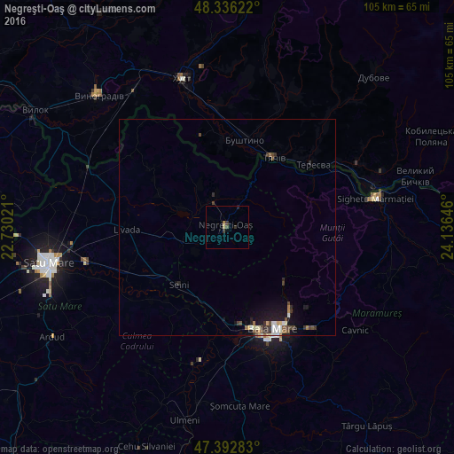
Analysis of Negreşti-Oaş night lights 2016
Square area 10x10 km:
 0%
0%90-99
0%80-89
0.57%70-79
0.14%60-69
0.43%50-59
0%40-49
0.71%30-39
1.56%20-29
0.28%10-19
0.28%0-9
96.02%Square area 50x50 km:
0.14%90-99
0.26%80-89
0.14%70-79
0.1%60-69
0.14%50-59
0.16%40-49
0.35%30-39
0.37%20-29
0.25%10-19
1.15%0-9
96.95%Clear (daylight) street map image can be seen on geolist.org.
Map coordinates:
48° 20' 10.4" North, 22° 43' 48.8" East
47° 52' 0" North, 23° 25' 60" East
47° 23' 34.2" North, 24° 8' 11.3" East
Some cities around Negreşti-Oaş sort by population:
• Seini
17.1 km =10.6 mi,  220°
220°
• Tyachiv, UA
19.1 km =11.9 mi,  32°
32°
• Bushtyno, UA
20.9 km =13 mi,  10°
10°
• Vyshkovo, UA
20.3 km =12.6 mi,  357°
357°
• Bixad
7.8 km =4.8 mi,  341°
341°
• Oraşu Nou
11.8 km =7.3 mi,  251°
251°
• Turţ
20.7 km =12.9 mi,  308°
308°
• Certeze
4.5 km =2.8 mi, 33°
672365 (p: 13,456)
Sources (retrieved 2019-11-25):
» Earth at Night: Flat Maps 2012, 2016