Cisnădie night lights from space
Night Light of Cisnădie (Sibiu) from space (Romania) Src. Average luminocity for 10x10km area is 13.3182% and for 50x50km: 3.5192%.
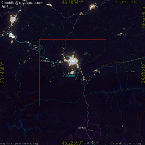
Analysis of Cisnădie night lights 2016
Square area 10x10 km:
 0.91%
0.91%90-99
0.61%80-89
1.21%70-79
1.21%60-69
0.61%50-59
2.42%40-49
0.91%30-39
0.61%20-29
11.21%10-19
22.73%0-9
57.58%Square area 50x50 km:
0.72%90-99
0.62%80-89
0.26%70-79
0.22%60-69
0.32%50-59
0.43%40-49
0.31%30-39
0.43%20-29
1.47%10-19
2.83%0-9
92.38%Clear (daylight) street map image can be seen on geolist.org.
Map coordinates:
46° 12' 19.6" North, 23° 26' 48.8" East
45° 43' 0" North, 24° 9' 0" East
45° 13' 24.9" North, 24° 51' 11.3" East
Some cities around Cisnădie sort by population:
• Sibiu
9.3 km =5.8 mi,  0°
0°
• Avrig
18.1 km =11.2 mi,  90°
90°
• Victoria
42.9 km =26.7 mi, 88°
• Brezoi
42.8 km =26.6 mi,  169°
169°
• Tălmaciu
10.5 km =6.5 mi,  121°
121°
• Sălişte
22.3 km =13.9 mi,  293°
293°
• Răşinari
6.7 km =4.2 mi,  254°
254°
• Copşa Mică
45.1 km =28 mi,  9°
9°
681502 (p: 15,042)
Sources (retrieved 2019-11-25):
» Earth at Night: Flat Maps 2012, 2016