Mijdrecht night lights from space
Night Light of Mijdrecht (Utrecht) from space (Netherlands) Src. Average luminocity for 10x10km area is 29.7421% and for 50x50km: 47.9851%.
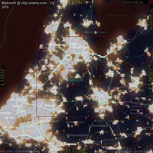
Analysis of Mijdrecht night lights 2016
Square area 10x10 km:
 3.31%
3.31%90-99
4.89%80-89
2.12%70-79
3.7%60-69
3.31%50-59
3.97%40-49
6.08%30-39
5.42%20-29
13.1%10-19
26.59%0-9
27.51%Square area 50x50 km:
14.86%90-99
11.84%80-89
3.15%70-79
3.74%60-69
4.73%50-59
4.48%40-49
5.63%30-39
7.14%20-29
11.95%10-19
14.5%0-9
17.98%Clear (daylight) street map image can be seen on geolist.org.
Map coordinates:
52° 38' 7.7" North, 4° 9' 33.8" East
52° 12' 24" North, 4° 51' 45" East
51° 46' 25.3" North, 5° 33' 56.3" East
Some cities around Mijdrecht sort by population:
• Uithoorn
4.2 km =2.6 mi,  324°
324°
• Aalsmeer
9.1 km =5.7 mi,  309°
309°
• Breukelen
10.1 km =6.3 mi,  110°
110°
• Kudelstaart
8.2 km =5.1 mi,  291°
291°
• Ouderkerk aan de Amstel
10.3 km =6.4 mi,  17°
17°
• Oosteinde
9.3 km =5.8 mi,  330°
330°
• Abcoude
10.3 km =6.4 mi,  44°
44°
• Wilnis
2.6 km =1.6 mi,  115°
115°
2750815 (p: 15,230)
Sources (retrieved 2019-11-25):
» Earth at Night: Flat Maps 2012, 2016