Goor night lights from space
Night Light of Goor (Overijssel) from space (Netherlands) Src. Average luminocity for 10x10km area is 6.1336% and for 50x50km: 9.5976%.
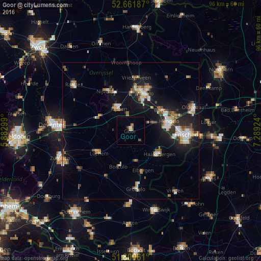
Analysis of Goor night lights 2016
Square area 10x10 km:
100  0.79%
0.79%
90-99 0.26%
80-89 0.53%
70-79 0.66%
60-69 0.93%
50-59 1.85%
40-49 0.79%
30-39 0%
20-29 1.06%
10-19 0.53%
0-9 92.59%
0.79%90-99
0.26%80-89
0.53%70-79
0.66%60-69
0.93%50-59
1.85%40-49
0.79%30-39
0%20-29
1.06%10-19
0.53%0-9
92.59%Square area 50x50 km:
100 1.24%
90-99 1.45%
80-89 0.78%
70-79 1.03%
60-69 1.34%
50-59 1.41%
40-49 1.44%
30-39 0.87%
20-29 2.44%
10-19 7.64%
0-9 80.37%
1.24%90-99
1.45%80-89
0.78%70-79
1.03%60-69
1.34%50-59
1.41%40-49
1.44%30-39
0.87%20-29
2.44%10-19
7.64%0-9
80.37%Clear (daylight) street map image can be seen on geolist.org.
Map coordinates:
52° 39' 42.7" North, 5° 52' 58.8" East
52° 13' 60" North, 6° 35' 10" East
51° 48' 2.2" North, 7° 17' 21.3" East
Some cities around Goor sort by population:
• Hengelo
14.5 km =9 mi,  75°
75°
• Haaksbergen
13.5 km =8.4 mi,  129°
129°
• Wierden
14 km =8.7 mi,  1°
1°
• Borne
13.4 km =8.3 mi,  55°
55°
• Lochem
14.5 km =9 mi,  235°
235°
• Borculo
13.8 km =8.6 mi,  198°
198°
• Neede
11.2 km =7 mi,  170°
170°
• Delden
9 km =5.6 mi,  70°
70°
2755449 (p: 11,460)
Sources (retrieved 2019-11-25):
» Earth at Night: Flat Maps 2012, 2016