Emmerhout night lights from space
Night Light of Emmerhout (Drenthe) from space (Netherlands) Src. Average luminocity for 10x10km area is 19.5429% and for 50x50km: 2.9813%.
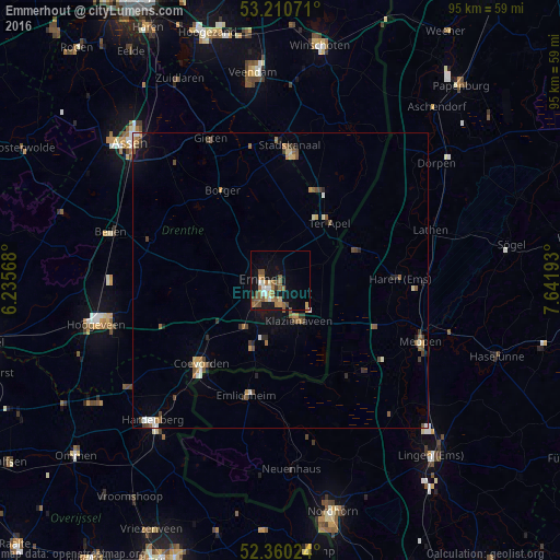
Analysis of Emmerhout night lights 2016
Square area 10x10 km:
 2.27%
2.27%90-99
1.89%80-89
1.89%70-79
1.26%60-69
5.43%50-59
6.31%40-49
2.9%30-39
0.63%20-29
0%10-19
17.42%0-9
59.97%Square area 50x50 km:
0.28%90-99
0.34%80-89
0.23%70-79
0.35%60-69
0.47%50-59
0.76%40-49
0.53%30-39
0.46%20-29
0.31%10-19
1.32%0-9
94.95%Clear (daylight) street map image can be seen on geolist.org.
Map coordinates:
53° 12' 38.6" North, 6° 14' 8.4" East
52° 47' 15.2" North, 6° 56' 19.7" East
52° 21' 36.9" North, 7° 38' 30.9" East
Some cities around Emmerhout sort by population:
• Emmen
2.3 km =1.4 mi,  246°
246°
• Haren, DE
20.4 km =12.7 mi,  88°
88°
• Stadskanaal
22.5 km =14 mi,  1°
1°
• Coevorden
19.4 km =12.1 mi,  223°
223°
• Klazienaveen
7.9 km =4.9 mi,  153°
153°
• Bargeres
4.8 km =3 mi,  233°
233°
• Angelslo
1.1 km =0.7 mi, 228°
• Emlichheim, DE
19.9 km =12.4 mi,  197°
197°
2756128 (p: 7,375)
Sources (retrieved 2019-11-25):
» Earth at Night: Flat Maps 2012, 2016