Songgangdong night lights from space
Night Light of Songgangdong (Daejeon) from space (South Korea) Src. Average luminocity for 10x10km area is 76.271% and for 50x50km: 37.9654%.
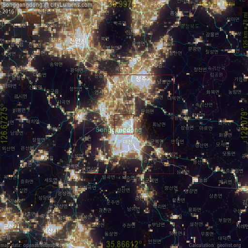
Analysis of Songgangdong night lights 2016
Square area 10x10 km:
 21.15%
90-99
23.6%80-89
8.57%70-79
8.74%60-69
7.52%50-59
9.09%40-49
13.99%30-39
7.34%20-29
0%10-19
0%0-9
0%Square area 50x50 km:
6.12%90-99
7.59%80-89
3.7%70-79
4.46%60-69
6.27%50-59
7.01%40-49
6.26%30-39
7.26%20-29
8.34%10-19
14.36%0-9
28.64%Clear (daylight) street map image can be seen on geolist.org.
Map coordinates:
36° 59' 51" North, 126° 40' 21.9" East
36° 26' 1.9" North, 127° 22' 33.1" East
35° 51' 58" North, 128° 4' 44.4" East
Some cities around Songgangdong sort by population:
• Daejeon
9.5 km =5.9 mi,  175°
175°
• Cheongju-si
24.8 km =15.4 mi,  24°
24°
• Sejong
19.2 km =11.9 mi,  337°
337°
• Gongju
22.6 km =14 mi,  276°
276°
• Okcheon
22.7 km =14.1 mi,  130°
130°
• Nonsan
36.5 km =22.7 mi,  225°
225°
• Kinzan
38.2 km =23.7 mi,  164°
164°
• Sintansin
5.4 km =3.4 mi,  66°
66°
6888788 (p: 10,000)
Sources (retrieved 2019-11-25):
» Earth at Night: Flat Maps 2012, 2016