Zelarino night lights from space
Night Light of Zelarino (Veneto) from space (Italy) Src. Average luminocity for 10x10km area is 84.3455% and for 50x50km: 44.5371%.
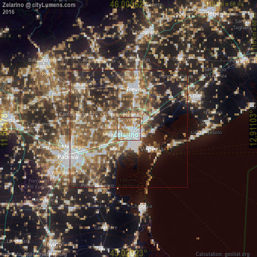
Analysis of Zelarino night lights 2016
Square area 10x10 km:
 32.12%
90-99
22.88%80-89
4.7%70-79
11.21%60-69
18.33%50-59
8.94%40-49
1.82%30-39
0%20-29
0%10-19
0%0-9
0%Square area 50x50 km:
7.07%90-99
8.51%80-89
4.16%70-79
5.28%60-69
8.1%50-59
10.32%40-49
8.83%30-39
7.82%20-29
9.81%10-19
10.05%0-9
20.05%Clear (daylight) street map image can be seen on geolist.org.
Map coordinates:
46° 0' 20.2" North, 11° 30' 17.2" East
45° 30' 54.3" North, 12° 12' 28.4" East
45° 1' 12.8" North, 12° 54' 39.7" East
Some cities around Zelarino sort by population:
• Mestre
3.9 km =2.4 mi,  131°
131°
• Spinea-Orgnano
4.9 km =3 mi,  237°
237°
• Mogliano Veneto
5.3 km =3.3 mi,  30°
30°
• Mirano
8.1 km =5 mi,  253°
253°
• Marcon-Gaggio-Colmello
9 km =5.6 mi,  52°
52°
• Salzano
8.3 km =5.2 mi,  275°
275°
• Martellago
4.7 km =2.9 mi,  312°
312°
• Maerne
4.2 km =2.6 mi, 282°
3163898 (p: 5,260)
Sources (retrieved 2019-11-25):
» Earth at Night: Flat Maps 2012, 2016