Spinetta Marengo night lights from space
Night Light of Spinetta Marengo (Piedmont) from space (Italy) Src. Average luminocity for 10x10km area is 33.381% and for 50x50km: 16.2937%.
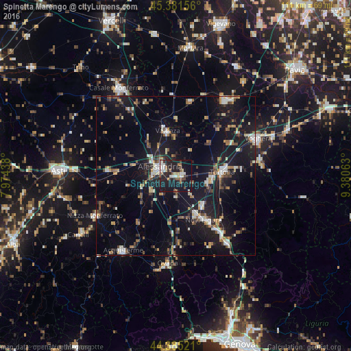
Analysis of Spinetta Marengo night lights 2016
Square area 10x10 km:
 6.19%
6.19%90-99
5.56%80-89
2.7%70-79
2.06%60-69
4.6%50-59
3.33%40-49
2.86%30-39
4.29%20-29
15.56%10-19
46.35%0-9
6.51%Square area 50x50 km:
1.73%90-99
2.34%80-89
1.26%70-79
1.47%60-69
2.08%50-59
1.99%40-49
2.63%30-39
2.15%20-29
3.78%10-19
20.59%0-9
60%Clear (daylight) street map image can be seen on geolist.org.
Map coordinates:
45° 22' 53.6" North, 7° 58' 27.8" East
44° 53' 7.9" North, 8° 40' 39" East
44° 23' 6.8" North, 9° 22' 50.3" East
Some cities around Spinetta Marengo sort by population:
• Alessandria
5.9 km =3.7 mi,  296°
296°
• Novi Ligure
16.2 km =10.1 mi,  147°
147°
• Tortona
14.7 km =9.1 mi,  84°
84°
• Valenza
14.4 km =8.9 mi,  349°
349°
• Ovada
27.7 km =17.2 mi,  185°
185°
• Nizza Monferrato
28.1 km =17.5 mi,  243°
243°
• Mede
23.9 km =14.9 mi,  11°
11°
• Serravalle Scrivia
22.9 km =14.2 mi,  142°
142°
3166243 (p: 6,392)
Sources (retrieved 2019-11-25):
» Earth at Night: Flat Maps 2012, 2016