San Nicola la Strada night lights from space
Night Light of San Nicola la Strada (Campania) from space (Italy) Src. Average luminocity for 10x10km area is 88.1259% and for 50x50km: 49.6099%.

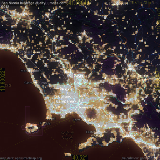
Analysis of San Nicola la Strada night lights 2016
Square area 10x10 km:
 32.14%
90-99
34.69%80-89
7.99%70-79
7.48%60-69
9.35%50-59
3.57%40-49
2.21%30-39
2.38%20-29
0.17%10-19
0%0-9
0%Square area 50x50 km:
11.98%90-99
11.76%80-89
4.93%70-79
6.21%60-69
7.54%50-59
5.93%40-49
4.4%30-39
5.98%20-29
9.81%10-19
15.28%0-9
16.18%Clear (daylight) street map image can be seen on geolist.org.
Map coordinates:
41° 34' 49.7" North, 13° 37' 48.8" East
41° 3' 8.5" North, 14° 20' 0" East
40° 31' 12" North, 15° 2' 11.3" East
Some cities around San Nicola la Strada sort by population:
• Caserta
2.3 km =1.4 mi,  357°
357°
• Marcianise
3.8 km =2.4 mi,  230°
230°
• Maddaloni
4.5 km =2.8 mi,  114°
114°
• Casagiove
2.8 km =1.7 mi,  319°
319°
• Capodrise
2.5 km =1.6 mi,  244°
244°
• Recale
2.6 km =1.6 mi,  281°
281°
• Portico di Caserta
4.5 km =2.8 mi,  274°
274°
• San Marco Evangelista
1.8 km =1.1 mi,  162°
162°
6534253 (p: 21,147)
Sources (retrieved 2019-11-25):
» Earth at Night: Flat Maps 2012, 2016