Montanaro night lights from space
Night Light of Montanaro (Piedmont) from space (Italy) Src. Average luminocity for 10x10km area is 37.7227% and for 50x50km: 31.0623%.
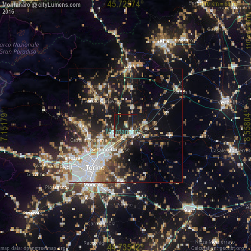
Analysis of Montanaro night lights 2016
Square area 10x10 km:
 7.12%
7.12%90-99
5.45%80-89
6.36%70-79
2.88%60-69
1.06%50-59
3.79%40-49
5.45%30-39
5%20-29
21.36%10-19
40%0-9
1.52%Square area 50x50 km:
6.65%90-99
6.15%80-89
2.36%70-79
3.14%60-69
3.29%50-59
4.73%40-49
4.29%30-39
4.55%20-29
7.59%10-19
19.73%0-9
37.52%Clear (daylight) street map image can be seen on geolist.org.
Map coordinates:
45° 43' 32.7" North, 7° 9' 6.4" East
45° 13' 57.9" North, 7° 51' 17.7" East
44° 44' 7.5" North, 8° 33' 28.9" East
Some cities around Montanaro sort by population:
• Settimo Torinese
12.3 km =7.6 mi,  212°
212°
• Chivasso
5.4 km =3.4 mi,  149°
149°
• Volpiano
7.2 km =4.5 mi,  239°
239°
• Leini
12.3 km =7.6 mi, 243°
• Brandizzo
6.4 km =4 mi,  193°
193°
• Gassino Torinese
11.7 km =7.3 mi, 189°
• San Benigno Canavese
5.6 km =3.5 mi,  262°
262°
• Caluso
8.5 km =5.3 mi,  19°
19°
3173074 (p: 5,244)
Sources (retrieved 2019-11-25):
» Earth at Night: Flat Maps 2012, 2016