Airali night lights from space
Night Light of Airali (Piedmont) from space (Italy) Src. Average luminocity for 10x10km area is 21.273% and for 50x50km: 11.1286%.
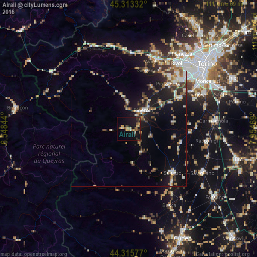
Analysis of Airali night lights 2016
Square area 10x10 km:
 0%
0%90-99
2.22%80-89
3.17%70-79
4.13%60-69
3.02%50-59
4.6%40-49
0.95%30-39
4.6%20-29
1.75%10-19
31.27%0-9
44.29%Square area 50x50 km:
1.16%90-99
2.1%80-89
1%70-79
1.18%60-69
1.4%50-59
1.4%40-49
1.78%30-39
1.59%20-29
2.27%10-19
10.48%0-9
75.65%Clear (daylight) street map image can be seen on geolist.org.
Map coordinates:
45° 18' 48" North, 6° 32' 54.4" East
44° 49' 0.1" North, 7° 15' 5.7" East
44° 18' 56.8" North, 7° 57' 16.9" East
Some cities around Airali sort by population:
• Pinerolo
9.9 km =6.2 mi,  39°
39°
• Piossasco
25.2 km =15.7 mi, 40°
• Saluzzo
26.9 km =16.7 mi,  134°
134°
• Giaveno
26.4 km =16.4 mi,  16°
16°
• Bruino
28.3 km =17.6 mi, 38°
• None
26.3 km =16.3 mi,  59°
59°
• Volvera
25.6 km =15.9 mi,  53°
53°
• Cumiana
20.3 km =12.6 mi,  29°
29°
8948778 (p: 5,619)
Sources (retrieved 2019-11-25):
» Earth at Night: Flat Maps 2012, 2016