Saint-Avold night lights from space
Night Light of Saint-Avold (Grand Est) from space (France) Src. Average luminocity for 10x10km area is 43.3627% and for 50x50km: 16.4276%.
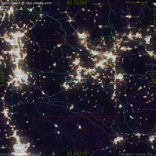
Analysis of Saint-Avold night lights 2016
Square area 10x10 km:
 9.94%
9.94%90-99
8.68%80-89
4.2%70-79
3.92%60-69
3.78%50-59
3.92%40-49
1.54%30-39
7.42%20-29
24.93%10-19
29.83%0-9
1.82%Square area 50x50 km:
2.54%90-99
2.85%80-89
1.32%70-79
1.55%60-69
1.91%50-59
2%40-49
2.3%30-39
3%20-29
6.86%10-19
13.68%0-9
61.99%Clear (daylight) street map image can be seen on geolist.org.
Map coordinates:
49° 33' 46.2" North, 6° 0' 3.2" East
49° 6' 16.7" North, 6° 42' 14.5" East
48° 38' 31.9" North, 7° 24' 25.7" East
Some cities around Saint-Avold sort by population:
• Freyming-Merlebach
7.7 km =4.8 mi,  48°
48°
• Creutzwald
11.2 km =7 mi,  357°
357°
• Überherrn, DE
15.3 km =9.5 mi, 358°
• Hombourg-Haut
5.5 km =3.4 mi,  61°
61°
• Großrosseln, DE
14.8 km =9.2 mi,  42°
42°
• Farébersviller
12.1 km =7.5 mi,  82°
82°
• Ludweiler-Warndt, DE
15.1 km =9.4 mi,  31°
31°
• Faulquemont
9.9 km =6.2 mi,  231°
231°
2981492 (p: 18,281)
Sources (retrieved 2019-11-25):
» Earth at Night: Flat Maps 2012, 2016