Beauchamp night lights from space
Night Light of Beauchamp (Île-de-France) from space (France) Src. Average luminocity for 10x10km area is 80.747% and for 50x50km: 55.7442%.
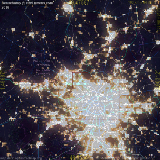
Analysis of Beauchamp night lights 2016
Square area 10x10 km:
 28.87%
90-99
22.17%80-89
13.84%70-79
7.59%60-69
8.33%50-59
4.91%40-49
3.13%30-39
7.14%20-29
4.02%10-19
0%0-9
0%Square area 50x50 km:
25.07%90-99
11.55%80-89
4.11%70-79
4.01%60-69
4.33%50-59
3.93%40-49
5%30-39
4.42%20-29
7.93%10-19
13.29%0-9
16.37%Clear (daylight) street map image can be seen on geolist.org.
Map coordinates:
49° 28' 32.4" North, 1° 29' 48.7" East
49° 1' 0" North, 2° 12' 0" East
48° 33' 12.2" North, 2° 54' 11.2" East
Some cities around Beauchamp sort by population:
• Franconville
4.4 km =2.7 mi,  146°
146°
• Taverny
1.6 km =1 mi,  51°
51°
• Herblay
3.7 km =2.3 mi,  216°
216°
• Montigny-lès-Cormeilles
3.9 km =2.4 mi,  179°
179°
• Saint-Leu-la-Forêt
3.6 km =2.2 mi,  90°
90°
• Bessancourt
2.4 km =1.5 mi,  16°
16°
• Le Plessis-Bouchard
3.1 km =1.9 mi,  127°
127°
• Pierrelaye
3.3 km =2.1 mi,  278°
278°
3034369 (p: 9,532)
Sources (retrieved 2019-11-25):
» Earth at Night: Flat Maps 2012, 2016