Lapinlahti night lights from space
Night Light of Lapinlahti (Northern Savonia) from space (Finland) Src. Average luminocity for 10x10km area is 12.7014% and for 50x50km: 2.9472%.
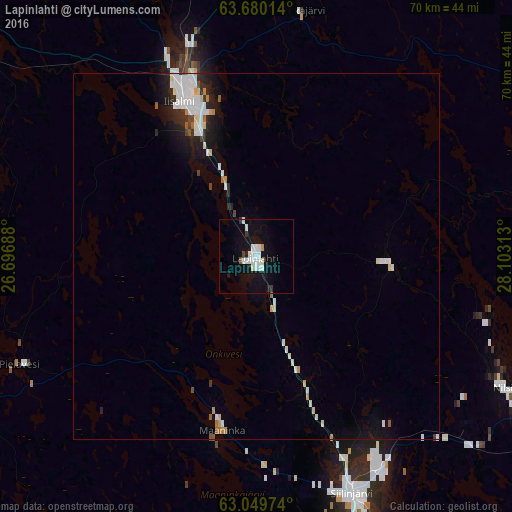
Analysis of Lapinlahti night lights 2016
Square area 10x10 km:
 3.67%
3.67%90-99
3.57%80-89
0.5%70-79
0.4%60-69
0%50-59
0.3%40-49
0.5%30-39
0.79%20-29
0.6%10-19
13.99%0-9
75.69%Square area 50x50 km:
0.71%90-99
0.83%80-89
0.24%70-79
0.14%60-69
0.14%50-59
0.17%40-49
0.14%30-39
0.19%20-29
0.58%10-19
1.88%0-9
94.98%Clear (daylight) street map image can be seen on geolist.org.
Map coordinates:
63° 40' 48.5" North, 26° 41' 48.8" East
63° 22' 0" North, 27° 24' 0" East
63° 2' 59.1" North, 28° 6' 11.3" East
Some cities around Lapinlahti sort by population:
• Kuopio
54.5 km =33.9 mi,  165°
165°
• Iisalmi
23.8 km =14.8 mi,  334°
334°
• Siilinjärvi
34.2 km =21.3 mi,  157°
157°
• Kiuruvesi
50 km =31.1 mi,  309°
309°
• Nilsiä
38.4 km =23.9 mi,  117°
117°
• Pyhäjärvi
81.5 km =50.6 mi,  294°
294°
• Pielavesi
35.7 km =22.2 mi,  245°
245°
• Juankoski
58.1 km =36.1 mi,  125°
125°
648953 (p: 7,350)
Sources (retrieved 2019-11-25):
» Earth at Night: Flat Maps 2012, 2016