Villa del Río night lights from space
Night Light of Villa del Río (Andalusia) from space (Spain) Src. Average luminocity for 10x10km area is 6.3523% and for 50x50km: 3.2422%.
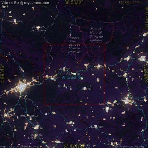
Analysis of Villa del Río night lights 2016
Square area 10x10 km:
 0.81%
0.81%90-99
0.49%80-89
1.95%70-79
0%60-69
1.3%50-59
0.16%40-49
1.79%30-39
0%20-29
0.49%10-19
0.16%0-9
92.86%Square area 50x50 km:
0.27%90-99
0.48%80-89
0.49%70-79
0.42%60-69
0.42%50-59
0.47%40-49
0.39%30-39
0.44%20-29
0.37%10-19
0.33%0-9
95.93%Clear (daylight) street map image can be seen on geolist.org.
Map coordinates:
38° 31' 59.5" North, 4° 59' 35.4" West
37° 58' 51.9" North, 4° 17' 24.1" West
37° 25' 29.2" North, 3° 35' 12.9" West
Some cities around Villa del Río sort by population:
• Andújar
21.9 km =13.6 mi,  72°
72°
• Torredonjimeno
37.6 km =23.4 mi,  129°
129°
• Montoro
9.5 km =5.9 mi,  300°
300°
• Castro del Río
36.3 km =22.6 mi,  207°
207°
• Bujalance
12.4 km =7.7 mi,  219°
219°
• Marmolejo
12.7 km =7.9 mi,  55°
55°
• Porcuna
15.3 km =9.5 mi,  143°
143°
• Arjona
21.3 km =13.2 mi,  103°
103°
2509603 (p: 7,407)
Sources (retrieved 2019-11-25):
» Earth at Night: Flat Maps 2012, 2016