Meaño night lights from space
Night Light of Meaño (Galicia) from space (Spain) Src. Average luminocity for 10x10km area is 54.4206% and for 50x50km: 27.2868%.
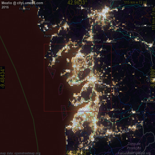
Analysis of Meaño night lights 2016
Square area 10x10 km:
 2.7%
2.7%90-99
11.11%80-89
8.73%70-79
7.46%60-69
9.84%50-59
11.43%40-49
9.68%30-39
17.14%20-29
21.9%10-19
0%0-9
0%Square area 50x50 km:
2.29%90-99
5.29%80-89
3.43%70-79
3.44%60-69
4.32%50-59
4.19%40-49
3.6%30-39
5.31%20-29
12.46%10-19
15.2%0-9
40.47%Clear (daylight) street map image can be seen on geolist.org.
Map coordinates:
42° 57' 47.9" North, 9° 29' 3.6" West
42° 26' 47.8" North, 8° 46' 52.4" West
41° 55' 32.2" North, 8° 4' 41.1" West
Some cities around Meaño sort by population:
• Pontevedra
11.4 km =7.1 mi,  98°
98°
• Marín
9 km =5.6 mi,  133°
133°
• Sanxenxo
5.6 km =3.5 mi,  202°
202°
• Poio
7.8 km =4.8 mi,  89°
89°
• Cambados
7.7 km =4.8 mi,  340°
340°
• Bueu
13.6 km =8.5 mi,  181°
181°
• O Grove
8.7 km =5.4 mi,  307°
307°
• Vilanova de Arousa
13.6 km =8.5 mi, 343°
3117048 (p: 5,505)
Sources (retrieved 2019-11-25):
» Earth at Night: Flat Maps 2012, 2016