el Congrés i els Indians night lights from space
Night Light of el Congrés i els Indians (Catalonia) from space (Spain) Src. Average luminocity for 10x10km area is 90.6803% and for 50x50km: 44.3535%.
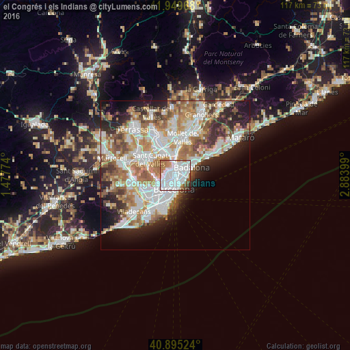
Analysis of el Congrés i els Indians night lights 2016
Square area 10x10 km:
 52.89%
90-99
23.81%80-89
1.36%70-79
5.78%60-69
7.31%50-59
5.1%40-49
2.21%30-39
1.02%20-29
0.51%10-19
0%0-9
0%Square area 50x50 km:
11.75%90-99
10.66%80-89
4.24%70-79
5.19%60-69
8.02%50-59
5.89%40-49
3.67%30-39
4.16%20-29
7.74%10-19
7.76%0-9
30.92%Clear (daylight) street map image can be seen on geolist.org.
Map coordinates:
41° 56' 58.8" North, 1° 28' 39.9" East
41° 25' 28.6" North, 2° 10' 51.1" East
40° 53' 42.9" North, 2° 53' 2.4" East
Some cities around el Congrés i els Indians sort by population:
• Horta-Guinardó
1.3 km =0.8 mi,  238°
238°
• el Guinardó
0.9 km =0.6 mi,  223°
223°
• La Sagrera
0.5 km =0.3 mi,  116°
116°
• Vilapicina i la Torre Llobeta
0.7 km =0.4 mi,  308°
308°
• Porta
1.2 km =0.7 mi,  351°
351°
• Navas
0.8 km =0.5 mi,  149°
149°
• el Turó de la Peira
1.3 km =0.8 mi, 310°
• la Font d'en Fargues
1.3 km =0.8 mi,  270°
270°
11549800 (p: 14,161)
Sources (retrieved 2019-11-25):
» Earth at Night: Flat Maps 2012, 2016