Canovelles night lights from space
Night Light of Canovelles (Catalonia) from space (Spain) Src. Average luminocity for 10x10km area is 69.4123% and for 50x50km: 35.805%.
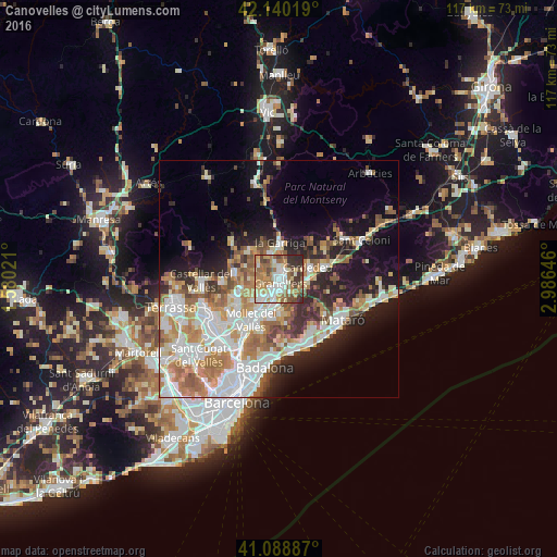
Analysis of Canovelles night lights 2016
Square area 10x10 km:
 11.04%
90-99
16.88%80-89
10.23%70-79
10.39%60-69
17.37%50-59
9.42%40-49
11.69%30-39
8.12%20-29
4.87%10-19
0%0-9
0%Square area 50x50 km:
8.03%90-99
8.09%80-89
3.99%70-79
4.7%60-69
6.46%50-59
4.33%40-49
3.29%30-39
3.23%20-29
6.3%10-19
11.33%0-9
40.26%Clear (daylight) street map image can be seen on geolist.org.
Map coordinates:
42° 8' 24.7" North, 1° 34' 48.8" East
41° 37' 0" North, 2° 16' 60" East
41° 5' 19.9" North, 2° 59' 11.3" East
Some cities around Canovelles sort by population:
• Granollers
1 km =0.6 mi,  159°
159°
• Parets del Vallès
6.3 km =3.9 mi,  221°
221°
• Cardedeu
6.7 km =4.2 mi,  67°
67°
• la Garriga
7.4 km =4.6 mi,  0°
0°
• Lliçà d'Amunt
4.2 km =2.6 mi,  270°
270°
• La Roca del Vallès
5.6 km =3.5 mi,  131°
131°
• L'Ametlla del Vallès
5.7 km =3.5 mi,  346°
346°
• Santa Eulàlia de Ronçana
5.6 km =3.5 mi,  311°
311°
3126534 (p: 16,023)
Sources (retrieved 2019-11-25):
» Earth at Night: Flat Maps 2012, 2016