Zavidovići night lights from space
Night Light of Zavidovići (Federation of B&H) from space (Bosnia and Herzegovina) Src. Average luminocity for 10x10km area is 2.7159% and for 50x50km: 1.2866%.
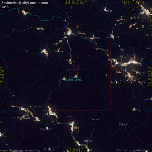
Analysis of Zavidovići night lights 2016
Square area 10x10 km:
 0.48%
0.48%90-99
0.16%80-89
0%70-79
0.63%60-69
0%50-59
0%40-49
1.27%30-39
1.27%20-29
0.63%10-19
0.63%0-9
94.92%Square area 50x50 km:
0.15%90-99
0.16%80-89
0.13%70-79
0.1%60-69
0.15%50-59
0.16%40-49
0.27%30-39
0.15%20-29
0.36%10-19
0.58%0-9
97.79%Clear (daylight) street map image can be seen on geolist.org.
Map coordinates:
44° 56' 44.3" North, 17° 26' 47.8" East
44° 26' 45" North, 18° 8' 59" East
43° 56' 30.1" North, 18° 51' 10.3" East
Some cities around Zavidovići sort by population:
• Žepče
9.1 km =5.7 mi,  256°
256°
• Tešanj
22.6 km =14 mi,  324°
324°
• Maglaj
12 km =7.5 mi,  340°
340°
• Kovači
4.4 km =2.7 mi,  85°
85°
• Gostovići
4.2 km =2.6 mi,  156°
156°
• Željezno Polje
17.4 km =10.8 mi,  252°
252°
• Blatnica
26.3 km =16.3 mi,  279°
279°
• Tešanjka
27.5 km =17.1 mi, 336°
3186717 (p: 14,380)
Sources (retrieved 2019-11-25):
» Earth at Night: Flat Maps 2012, 2016