Hazorasp night lights from space
Night Light of Hazorasp (Xorazm) from space (Uzbekistan) Src. Average luminocity for 10x10km area is 3.9167% and for 50x50km: 0.6138%.
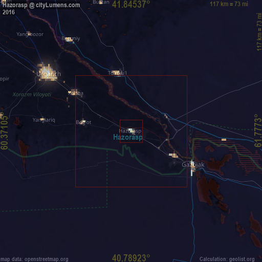
Analysis of Hazorasp night lights 2016
Square area 10x10 km:
 0%
0%90-99
1.36%80-89
0%70-79
1.36%60-69
0%50-59
0%40-49
0.34%30-39
1.19%20-29
2.21%10-19
0.34%0-9
93.2%Square area 50x50 km:
0%90-99
0.08%80-89
0.1%70-79
0.08%60-69
0.05%50-59
0.11%40-49
0.07%30-39
0.22%20-29
0.31%10-19
0.08%0-9
98.91%Clear (daylight) street map image can be seen on geolist.org.
Map coordinates:
41° 50' 43.3" North, 60° 22' 15.8" East
41° 19' 10" North, 61° 4' 27" East
40° 47' 21.2" North, 61° 46' 38.3" East
Some cities around Hazorasp sort by population:
• Urganch
44.8 km =27.8 mi,  304°
304°
• Khiwa
59.6 km =37 mi,  276°
276°
• Beruniy
49.2 km =30.6 mi,  327°
327°
• Novyy Turtkul’
26.1 km =16.2 mi,  349°
349°
• Gurlan
81.4 km =50.6 mi,  315°
315°
• Showot
74.4 km =46.2 mi, 300°
• Gazojak, TM
31.2 km =19.4 mi,  118°
118°
• Qŭshkŭpir
65.3 km =40.6 mi,  291°
291°
1513957 (p: 17,643)
Sources (retrieved 2019-11-25):
» Earth at Night: Flat Maps 2012, 2016