Akdepe night lights from space
Night Light of Akdepe (Daşoguz) from space (Turkmenistan) Src. Average luminocity for 10x10km area is 18.4508% and for 50x50km: 4.1807%.
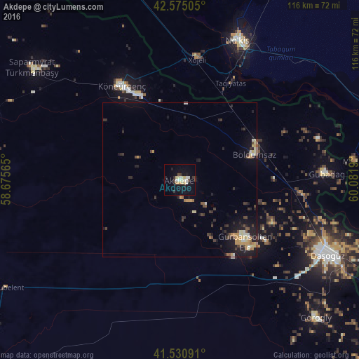
Analysis of Akdepe night lights 2016
Square area 10x10 km:
 2.54%
2.54%90-99
3.17%80-89
3.97%70-79
2.22%60-69
0.16%50-59
0.32%40-49
1.75%30-39
2.22%20-29
2.86%10-19
19.21%0-9
61.59%Square area 50x50 km:
0.18%90-99
0.6%80-89
0.63%70-79
0.82%60-69
0.29%50-59
0.26%40-49
0.63%30-39
0.83%20-29
1.21%10-19
3.51%0-9
91.03%Clear (daylight) street map image can be seen on geolist.org.
Map coordinates:
42° 34' 30.2" North, 58° 40' 32.3" East
42° 3' 18.5" North, 59° 22' 43.6" East
41° 31' 51.3" North, 60° 4' 54.8" East
Some cities around Akdepe sort by population:
• Nukus, UZ
48.2 km =30 mi,  23°
23°
• Daşoguz
54.4 km =33.8 mi,  116°
116°
• Xo‘jayli Shahri, UZ
39.7 km =24.7 mi,  7°
7°
• Manghit, UZ
56.6 km =35.2 mi,  83°
83°
• Köneürgench
35.5 km =22.1 mi,  328°
328°
• Yylanly
33.3 km =20.7 mi,  137°
137°
• Boldumsaz
25.4 km =15.8 mi,  71°
71°
• Tagta
63.3 km =39.3 mi, 135°
601551 (p: 14,177)
Sources (retrieved 2019-11-25):
» Earth at Night: Flat Maps 2012, 2016