Petit-Canal night lights from space
Night Light of Petit-Canal (Guadeloupe) from space (Guadeloupe) Src. Average luminocity for 10x10km area is 29.7252% and for 50x50km: 16.6261%.
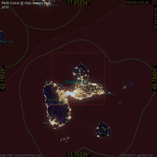
Analysis of Petit-Canal night lights 2016
Square area 10x10 km:
 1.24%
1.24%90-99
1.65%80-89
7.02%70-79
6.61%60-69
2.89%50-59
2.27%40-49
3.93%30-39
5.99%20-29
10.74%10-19
40.7%0-9
16.94%Square area 50x50 km:
1.53%90-99
1.6%80-89
2.86%70-79
3.63%60-69
1.95%50-59
1.62%40-49
3%30-39
3.69%20-29
5.86%10-19
11.07%0-9
63.19%Clear (daylight) street map image can be seen on geolist.org.
Map coordinates:
17° 3' 9.1" North, 62° 11' 25" West
16° 22' 44.9" North, 61° 29' 13.8" West
15° 42' 12.2" North, 60° 47' 2.5" West
Some cities around Petit-Canal sort by population:
• Les Abymes
12 km =7.5 mi,  189°
189°
• Baie-Mahault
16.3 km =10.1 mi,  220°
220°
• Le Gosier
19.2 km =11.9 mi,  181°
181°
• Le Moule
15.9 km =9.9 mi,  109°
109°
• Pointe-à-Pitre
16.2 km =10.1 mi,  198°
198°
• Lamentin
19.6 km =12.2 mi,  231°
231°
• Port-Louis
6.3 km =3.9 mi,  312°
312°
• Anse-Bertrand
10.6 km =6.6 mi,  348°
348°
3578681 (p: 8,554)
Sources (retrieved 2019-11-25):
» Earth at Night: Flat Maps 2012, 2016